Precision data. Powering progress.

Lay the foundation for your project’s success with quality surveying and spatial data.

Architecture & Heritage
Property Due Diligence
Government Geospatial
Government Infrastructure
Landfill Operations
Engineering & Construction
About landair

Landair Surveys delivers accurate surveying and spatial data for architects, government, property consultants, landfill managers and construction projects across the east coast of Australia.

With over 50 years of experience, we support projects of all sizes, from commercial developments to large-scale infrastructure. Whether you’re planning a site survey for construction, navigating a complex land development process, or requiring specialist civil survey solutions, our licensed surveyors provide reliable data to keep your project moving.

“We do a lot of complex work on complex sites. The reason Landair are our preferred and primary surveyor is that they hand us a product that is the quality that we need and others just don’t.”

Harry Jess, Co-founder and Architect at Conservation Studio

Who trusts us.

Work with a surveyor that’s been on the ground since 1974. Major organisations, from Victoria’s Department of Transport to Cleanaway, trust us with their spatial projects. 

Department of Transport Victoria
Spatial Services NSW
Holcim
Barro Group
CBRE Group
Goodman
Cleanaway
Architectus

Where we specialise.

We know what we do well and have operated in our expertise areas for decades. For your project, that means shorter turnaround times and fewer reworks compared to other surveyors.

Landair specialise

Architecture and heritage

Enhance architectural design by capturing intricate building details and site features.

“There’s a level of detail that Landair provides that others don’t in heritage.”
Max Bracher, Lovell Chen

Government geospatial

Deliver regular aerial data collection projects that assist with planning and development.

“Landair data is accurate, cloud-free and meets all our requirements.”
Amanda Secker, Department of Resources (QLD)

Government infrastructure

Provide precise data to manage and upgrade our roads, parks, waterways and public infrastructure.

“They always keep you updated. Landair are so easy to work with.”
Paul Goodison, Yarra Ranges Council

Property due diligence

Support consultants with time-sensitive site data and reports to enable informed decision-making.

“Explaining a Landair report to our clients is always easy. They’re so consistent.”
Simon Freeth, CBRE

Landfill operation

Assist operations with volumetric and infrastructure surveys to help manage landfill sites.

“Landair is very accurate and professional. I won’t use any other surveyor.”
Nino Frasca, The Barro Group

Engineering and construction

Work with engineers, construction partners and government agencies to complete building and civil projects.

“Landair has been an incredible partner for our business. They deliver exactly what we need.”
Armin Ghamami, 4Site

Our surveying services

From boundary and engineering surveys to 3D laser scanning, drone capture and volumetric reporting. Landair delivers the precise spatial data your project needs across Victoria and New South Wales.

3D Laser Scanning

Millimetre accurate point clouds of buildings, sites and assets for design, documentation and reality capture.

Drone & Aerial Surveys

Fast, safe aerial data capture and photogrammetry for large or hard to access sites.

Cadastral & Boundary Surveys

Licensed boundary, title and cadastral surveys for property, subdivision and development.

Engineering Surveys

Precise set out, feature and level surveys that keep construction on grid and on schedule.

Volumetric Surveys

Accurate stockpile, excavation and earthwork volumes for quarries, landfills and civil sites.

Underground Service Locating

Locate and map underground utilities before you design or dig, reducing risk and delay.

Get the quality data you’ve been missing, when you need it.

See us in action.

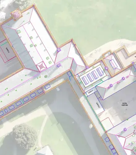
Werribee Park Mansion

Landair Surveys was chosen by heritage architects Lovell Chen to document the external conditions of the historic Werribee Park Mansion.

Werribee roof plan

What makes us different.

We’re a partner who quickly deploys experts to your project and focuses on a high standard of quality control, responding directly to your surveying and data needs.

2000+

Successful partnerships

50+

Years of surveying

5000+

Projects delivered

Capability Statement

View our capability statement

Let’s get started.